
WEST SUFFOLK PARISH #7: GAZELEY
Gazeley – “Gaegi’s Clearing”
Welcome back to West Suffolk again everyone and today we’re in Gazeley, another village that lies a couple of miles South of the A14 close to Newmarket. Surrounded on all sides by lush green countryside, its this village where the surnames Gazeley, Gazley and Gazlay all derive from. It depends how much of a romantic you are, but some locals think the village is so named because it literally “gazes” over the cathedral city of Ely. There is some credence to this theory because on a clear day you can see Ely’s cathedral on the horizon. Although we do love a bit of local folklore, in truth, it actually means “woodland clearing belong to Gaegi”.
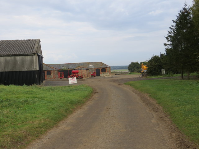
As well as Gazeley itself, the parish also contains the hamlet of Needham Street, as well as the site of two historical landmarks – Denham Castle and Desning Hall. It also has an old windmill and a central parish church too. The Icknield way passes through the middle of the village at Tithe Close. The area as a whole is focused on horse racing and the breeding and training of racehorses. Gazeley has a stud and a training yard.
Its the sort of place you could cycle through using Sustrans route 51, and imagine wistfully that you’ve won the lottery and could move to. Let’s see if I can sell it enough to convince anyone to relocate
****
#Gazeley, #Suffolk, #WestSuffolk, #Higham, #Moulton, #BuryStEdmunds, #Newmarket, #Racehorses, #Studs, #Racecourse, #Churches, #Windmills, #WaterTowers, #Football, #Cricket, #Wells, #Schools,
****
Denham Castle:

By Keith Evans, CC BY-SA 2.0, https://commons.wikimedia.org/w/index.php?curid=15683878
Desning Hall:
https://commons.wikimedia.org/wiki/File:Near_Desning_Hall_in_Suffolk_-_geograph.org.uk_-_39435.jpg
https://commons.wikimedia.org/w/index.php?curid=13163867
General information:
http://gazeley.onesuffolk.net/assets/Publications/InformationBookletv2.pdf
Chequers:
https://whatpub.com/pubs/WSB/324/chequers-gazeley
School:
https://www.get-information-schools.service.gov.uk/Establishments/Establishment/Details/124696
Needham Hall:
https://historicengland.org.uk/listing/the-list/list-entry/1037673?section=official-list-entry
Water Tower:
It's #WaterTowerWednesday – Here's Gazeley water tower near Newmarket, one of our smaller towers it holds 0.2 megalites pic.twitter.com/bzg9Ee8rY5
— Anglian Water (@AnglianWater) September 20, 2017
War memorial:
https://www.iwm.org.uk/memorials/item/memorial/4548
Church:
http://www.suffolkchurches.co.uk/gazeley.htm
General History:
http://gazeley.onesuffolk.net/the-village/
Demographics:
https://www.citypopulation.de/en/uk/eastofengland/admin/west_suffolk/E04009147__gazeley/
Rightmove:
https://www.rightmove.co.uk/house-prices/gazeley.html?page=1
Some of the following music tracks may appear in this video:
Brendan Perkins – “Foxsnow” (B. Perkins)
Brendan Perkins – “Mickey’s House” (B. Perkins)
The Keyhouse – “Voices” (H. Flunder)
The Keyhouse – “Circles” (H. Flunder)
Helen Flunder – “Sun” (H. Flunder)
Helen Flunder – “Angels” (H. Flunder)
Helen Flunder – “C Song” (H. Flunder)
I have me a Facebook page too!
https://www.facebook.com/The-Village-Idiot-226069228730989
And now an INSTAGRAM – @andythevillageidiot
Come and join The Village People! (Subscribers only!)
https://www.facebook.com/groups/1037756120085304
Please consider buying me a coffee to support the channel! The more I get the faster I’ll get to your parish! https://www.buymeacoffee.com/thevillageidiot
Join this channel to get access to perks:
https://www.youtube.com/channel/UCoCIZyD7knWk-ciKPRByuCA/join
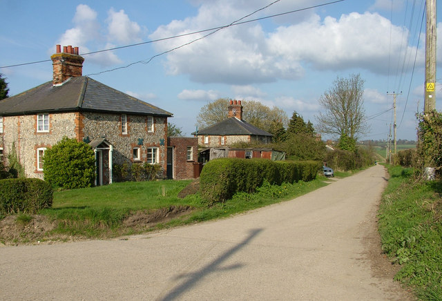
hello my name is Andy and I Am The Village Idiot I’m armed with a car and a GoPro and an unhealthy amount of time on my hands I’m using that time to attempt to visit every civil Parish in England you’re watching the West suffk series 103 parishes set in some of the most beautiful English Countryside and there’s some good ones in this area shall we go have a look of course welcome back to West suffk again folks time for another wander around this beautiful part of East Anglia today I brought you to a lovely Village and I know it’s lovely cuz I’ve just driven around it to start this episode off welcome to the Parish of [Music] gazley [Music] here’s my disclaimer for people who may be watching me for the first time I say things as I would in my native accent and dialect as a result I may not pronounce things in the same way as the locals do remember I’m a visitor it’s impossible to know everything leave me a comment spin me a like and Bash that subscribe button let’s get to today’s Parish video gazley gages clearing welcome back to West suffk again everyone and today we’re in gazley another Village that lies a couple of miles south of the A14 close to New Market surrounded on all sides by lush green Countryside it’s this village where the surnames gazley gazley and gazlay all derived from it depends how much of a romantic you are but some locals think the village is soam because it literally gazes over the cathedral city of elely there is some Credence to that theory because on a clear day you can see El’s Cathedral on the horizon although we do love a little bit of local folklore in truth it actually means Woodland clearing belonging to gagei as well as gazley itself the parish also contains the Hamlet of needam Street as well as the site of two historical landmarks Denon castle and desing Hall it also has an old windmill and a central Parish Church too the nneil way passes through the middle of the village at tithe close and the area as a whole is focused on horse racing and the breeding and training of race horses gazley has a stood and a training yard it’s the sort of place you could cycle through using sustrans Route 51 and imagine wistfully that you’ve won the lottery and you could move to let’s see if I can sell it enough to convince anyone to [Music] relocate [Music] before we walk anywhere we first have to discuss two important historical sites which within gazley Parish these are a Long Way to the southeast of the main settlement and are both inaccessible due to being on private roads the first is the site of desing Hall sometimes pronounced daning and historically called desing the manner of desing which once owned Gayle’s church was granted by William the Conqueror to Richard declair for 400 years from 1124 the Vicor of gazley was appointed by Stoke PRI which he controlled desing Hall a Saxon building no longer exists its last resident was slyy Arthur King who left the property in 1927 the house then stood vacant until the early 1980s when it was demolished All That Remains now are cottages and farm buildings the other landmark is the earthwork remains of a 12th century mton Bailey Castle named denim Castle or Castle Halls this was known as desing castle at the time of its construction there’ll be some more on this in the denim episode We Begin our journey around gazley on M Road its name is a reference to a tower Mill that stands to the north of the village which we’ll catch later the property ahead of us here is the Coach House which is sort of our end point later gazley is primarily a linear settlement it’s only within the last 80 years that this Arrangement has changed the oldest houses still line the Central Street whilst in at least three locations around around it there are areas of postwar housing all of The Village’s main landmarks lie around a central Village Green this is hyim Road a Windy Lane that runs to the neighboring Village we covered last week gazley lies in a valley below hyim meaning in places this road is certainly not flat we’re crossing a green here this is not the main Village Green because that’s near the church instead this one can be found at tithe close this is gle’s newest development having been built on the site of the Old Village allotments in the 1970s the allotments as a result were moved to the Northern end of gazley next to the local primary school now at this point I was supposed to follow a foot path which forms a neat little Loop onto the street the main road south towards Dum however this went slightly wrong I thought I was following the path but somehow it ended up in this abandoned farmyard not what I was intending luckily I could still carry on but it meant vaulting a gate to do so where exactly the path was supposed to come out I’m not totally sure but at least I was still in the right place this is the street and here we’re looking North back towards the Village Center next it’s the Highwood housing estate this was built onto the southwestern side of the village immediately after World War too most of it dates from the 1950s it’s a mixed estate of mostly private properties and some social the latter being managed by Flagship housing with the exception of tithe close and mil view this is the only major area of new housing that’s been added to gazley since wartime and it’s the biggest to boot its construction greatly increased the population so it’s a good thing there are some amenities in this Village at the end of stubbins Lane you’ll find one of gle’s two Recreation grounds this one has a playground and a big open Green Space the other one just south of the Highwood estate and alongside the street has facilities for both football and Cricket stubbins Lane is a lot older than the Highwood estate it has a few flintface properties common in suffk and one of The Village’s listed buildings namely the hutch it runs to the green before turning left but that’s where we’ll turn back on ourselves briefly to the right to catch the Village Hall gle’s village hall is right in the heart of civilization it was left in trust to the village in the 1930s and is run by a management committee various organizations use this on a regular basis including Dum and gazley wi the gazley History Society and a local Table Tennis Club the hall also offers excellent facilities for private hire it’s where the parish notice B can be found so tick off gazley folks that that’s 7 down and 996 to go dead opposite the hall we see a collection of newish houses as we turn around now towards the Central Village Green there are much older houses both on and around the green as you might expect given this is the oldest part of gazley it’s also where you can catch a bus gazley is served by the number 312 which runs between the towns of New Market and Berry St Edmond overlooking the green is the checkers a 400y old p Munson’s Brewery well known for their craft beers are based here the pub was commonly known as mson until the property was acquired by Green King Brewery and renamed the Checkers in the 1700s the green itself is a landmark this Stone was difficult to read but here you’re standing over a well which goes to an insane depth of 183 ft right beside it is the old red foam box but this one’s just an empty shell also on the green is an abandoned building which has seen better days Google street view shows this to have once been some sort of garage here also is a board that shows you the local foot paaths this mentions the popular three churches walk which takes in those at Dam and Molton as well as All Saints here in gazley All Saints is a grade one listed building dating back to the early 14th century it occupies a commanding position at the heart of the village and is the Central Church of its benefit one that contains five Villages it’s been a center of worship and Community celebration for over 800 years the church has undergone a program of repair and renovation over the past couple of decades in 2004 flood lighting and path lights were installed and these are sponsored by residents of The Village on a weekly basis there are regular Services here which are held twice a month this one was open too so let’s have a little look around here we’re in the Nave looking towards the chancel and the enormous East window one of the star features of a deliciously well-kept interior full of Interest some of the smaller features of this church such as its grotesques and corales have been cataloged by a photographer by the name of Simon Johnson and turned into a display seen here on the north wall of the Nave you’ll also find the war memorial this lists 15 names all local men who died in World War I as you leave the churchard you’ll pass this building the Old National School which was built in 1843 gazley no longer has an educational establishment it used to have a church of England School located on mil road but that closed in 2004 meaning the local children now have to travel elsewhere a few steps later and we pass a couple more notable old buildings both on the western side of the street these are firstly All Saints Vicor and then the building it replaced the old rectory which is right next door to the Coach House like neighboring hyim which used to be within gazley Parish the village is on sustrans Route 51 so the cyclists out there may well recognize this one here’s a quick look up Molton road which is where gazley stood and its Associated training yard is located I was loving this big red house on the corner by the way next to it is a vastly overgrown Pond something of a swamp at the moment it was nice though to imagine how it might once have looked as The Village’s focal point we’re back to milroad again now to make the short walk back to the car okay we’re back to where we began here at mil view we’re not quite done with gazley just yet though because there are two more things that I want to mention in this episode you see gazley also has a hamlet within its boundary is called Needum street so now we’re going to put the camera on the dash and take a drive through that when we’ve done that we’re going to head for the next Village and right on the parish boundary there’s a rather large Landmark that looms tall over this part of West suffk as you head north out of gazley you pass the old windmill you can’t really see it from this Direction but fear not on the way back you get a much better view first we’re off to the Hamlet of NM Street historically known simply as Needum it’s a linear settlement that spans about half a mile between gazley and kenford interchange on the A14 it’s a very rural place and has a total of just 10 properties and their Associated farm buildings you could so easily dismiss it as disinteresting however there is one listed building here the late 15th or early 16th century needam Hall which is Tim framed it was though unfortunately for us obstructed by trees nm’s Center is marked by a pretty little green let’s turn around here and make our way back to gazley bya the old Tower Mill it was built in 1837 by the very unfortunately named William death it was built to replace a former post Mill nearby when it was active it drove five pairs of millstones the mill ceased work in 1920 and it was stripped of its Machinery before eventually being converted into a house in 1947 the mill isn’t the only tall structure that Towers over gazley if you drive towards Molton you’ll be met with gazley water tower this is actually within Molton Parish but it’s right on the border it’s one of the smaller Towers operated by anglian water and it holds 0.2 megaliters when full time to move on that’s been gazley and I’ll see you in Molton next week for the final Parish in this run in West [Music] suffk [Music] thanks for watching this video folks don’t forget to like this episode if you haven’t already it really makes a difference with YouTube if you’re new here subscribe to the channel for more videos like this and give us a share too if you’ve got friends who’d like it you can find all the links to my social media accounts below as well as my buy me a coffee page where you can donate to the channel also if you’ve enjoyed this episode have a look at some more videos in this series until next time I’ve been Andy also known as The Village Idiot and I’m out
4 Comments
Really enjoying all the West Suffolk episodes Andy. I'm excited for when you get to Babergh. That's my local council area.
0:16 seconds in is my mums husbands family home.
Hi Andy…
Beautiful church..
Lots of lovely traditional houses.
Great video
Thanks
Wow.