
EAST RIDING OF YORKSHIRE PARISH #133: EASINGTON
Easington – “Farm of Esi’s people”
Welcome to the end of the East Riding. Don’t worry, there are still 39 more to go after this, but this is literally the county’s answer to Land’s End. This is Easington, which was one of the most complicated parishes to cover in the entire county. It consists of a main village – Easington itself – and a whole host of smaller settlements. However, a lot of those other settlements no longer exist.
Before coastal erosion had its way out here, Easington parish included places called Turmarr, Hoton, Northorpe, Dimlington, Old Kilnsea and Ravenser. These villages have been lost to the ever encroaching sea, some having disappeared as early as 1400. Dimlington’s name though still lives on thanks to a pair of Easington streets and one of the four gas terminals that dominate the coastline to the North of the village.
Two other settlements still survive though. One of them is Out Newton, which is just a couple of farms, but the other has one of the East Riding’s most well known landmarks. That would be Kilnsea, the last civilisation of any kind before the land becomes a spit, and stretches out into the Humber Estuary as the Spurn Heritage Coast. At four miles long, walking it would have been ridiculous, so I got myself a bike!
I must be mad. Keep watching to see how I got on
****
#EastRidingofYorkshire, #Yorkshire, #Hull, #Easington, #Kilnsea, #Spurn, #Coast, #Railways, #Coastguard, #Towers, #Churches, #Beaches, #Cycling, #Pubs, #Nature, #Seaside, #Sea, #Rivers, #Marshes, #RNLI, #Gas, #Norway, #Industry, #Geography, #Spits, #Island, #Caravans, #Lighthouse, #WWI, #Football,
****
Spurn:
https://www.yorkshirepost.co.uk/whats-on/arts-and-entertainment/point-of-no-return-1788616
Community Hall:
History:
http://www.easingtonparishcouncil.co.uk/history.aspx
Marquis of Granby:
https://whatpub.com/pubs/HUL/EAS001/marquis-of-granby-easington
White Horse:
https://whatpub.com/pubs/HUL/EAS003/white-horse-easington
Primitive Chapel:
War Memorial:
https://www.warmemorialsonline.org.uk/memorial/156946
Easington United:
https://www.facebook.com/EasingtonUtd/?locale=en_GB
https://www.theclubhq.com/easington-united-afc/about
Church:
https://www.britainexpress.com/attractions.htm?attraction=4642
Crown and Anchor:
https://whatpub.com/pubs/HUL/KIL003/crown-anchor-kilnsea
Kilnsea Wetlands:
https://www.ywt.org.uk/nature-reserves/kilnsea-wetlands-nature-reserve
Easington Beach:
The Tower:
Sound Mirror:
https://www.militaryhistories.co.uk/locations/view/4
https://www.bbc.co.uk/humber/content/articles/2008/10/15/kilnseaabandoned_feature.shtml
By Paul Glazzard, CC BY-SA 2.0, https://commons.wikimedia.org/w/index.php?curid=1667862
Demographics:
http://www.citypopulation.de/en/uk/yorkshireandthehumber/admin/east_riding_of_yorkshire/E04000381__easington/
Rightmove:
https://www.rightmove.co.uk/house-prices/easington-8850.html?page=1
Some of the following music tracks may appear in this video:
Brendan Perkins – “Foxsnow” (B. Perkins)
Brendan Perkins – “Mickey’s House” (B. Perkins)
The Keyhouse – “Voices” (H. Flunder)
The Keyhouse – “Circles” (H. Flunder)
Helen Flunder – “Sun” (H. Flunder)
Helen Flunder – “Angels” (H. Flunder)
Helen Flunder – “C Song” (H. Flunder)
I have me a Facebook page too!
https://www.facebook.com/The-Village-Idiot-226069228730989
And now an INSTAGRAM – @andythevillageidiot
Come and join The Village People! (Subscribers only!)
https://www.facebook.com/groups/1037756120085304
Please consider buying me a coffee to support the channel! The more I get the faster I’ll get to your parish! https://www.buymeacoffee.com/thevillageidiot
Join this channel to get access to perks:
https://www.youtube.com/channel/UCoCIZyD7knWk-ciKPRByuCA/join
Hello my name is Andy and I Am The Village Idiot I’m armed with a car and a GoPro and an unhealthy amount of time on my hands I’m using that time to attempt to visit every civil Parish in England you’re watching the East Riding of Yorkshire series together with the
Unparished city of Hull it forms the county of the same name there’s 172 parishes here which one are we in today now we have a saying in this country goes along the lines of it’s not what you know it’s who you know and thanks to Trevor howad right here the
Man who sponsors a lot of my videos I have a bike for this episode for easington and sperm point it’s a very fetching pink color but it’ll get me down spurn won’t it Trevor it will get you down spurn point from one end to the other no problem at all fantastic yeah
Welcome to the Parish of Easington Here’s my disclaimer for people who may be watching me for the first time I say things as I would in my native accent and dialect as a result I may not pronounce things in the same way as the locals do remember I’m a visitor it’s impossible to know everything leave me a
Comment spin me a like and Bash that subscribe button let’s get to today’s Parish video easington Farm of Essie’s people welcome to the end of the East Riding don’t worry there are still 39 more to go after this but this is literally the County’s answer to Land’s End this is
Easington which was one of the most complicated parishes to cover in the entire County it consists of a main village easington itself and a whole host of smaller settlements however a lot of those other settlements no longer exist before Coastal erosion had its way out here easington Parish included
Places called turmar hoton North or dimling old KY and ravener these Villages have been lost to the ever encroaching sea some having disappeared as early as 1400 dimling Ton’s name though still lives on thanks to a pair of easington streets and one of the four gas terminals that dominate the
Coastline to the north of the village two other settlement still survive though one of them is out Newton which is just a couple of farms but the other one has one of the East riding’s most well-known landmarks that would be Kiln SE the last civilization of any kind
Before the land becomes a spit and stretches out into the Humber estery as the spurn Heritage Coast at 4 mil long walking it would have been ridiculous so I got myself a bike I must be mad keep watching to see how I got on We Begin this fairly short walk around the main village at easington youth club right at the end of Beck Lane this is really the only Recreational facility The Village has featuring as it does a playground easy inton used to have a playing field but that’s now occupied by
A football club Beck Lane is a narrow dead end with Terraces although there is a small culdesac along here with some newer properties it runs from the center of the village known as the square which has long been eon’s main focal point at the end of the road we come to
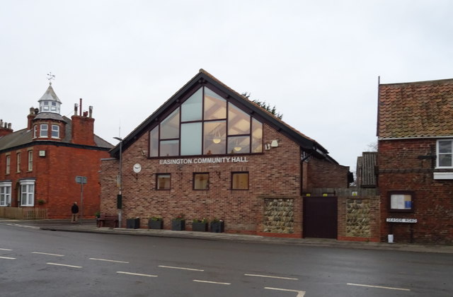
The easington Community Hall this is the village hall and in much the same way as you usual it’s frequented by various local groups and it’s available to hire I couldn’t find a date for its construction but you can probably tell it’s very modern outside the hall is the
Local bus stop easington is served by the number 71 to withy and the village is that route Southern Terminus if it tried to go much further well it would get wet and here we have the square a central area which is effectively a big car park overlooking the Central Square is
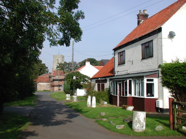
The church dedicated to All Saints it stands on a mound and dates back to Norman times originally that said it’s had a fair few additions over the centuries it has a 12th century North Isle a 13th century South aisle a 14th century clester and West Tower and a
15th century chancel it’s the church they just couldn’t stop building it seems set into the wall of the north aisle is an early English doorway that was brought here from Burl prior when the monastery sank into the Humber due to co Crystal erosion leaving the churchard were now
Out onto South Church side a Terrace Street which twists its way onto the High Street now at this point had I looked to the right I’d have seen what’s believed to be the oldest building in the village apart from the church on your screens now is a picture of the
Tithe Barn a 14th century thatched building which is the last example of its kind anywhere in haleness until the 1980s the barn was used used for hosting plays and the occasional wedding before that it was used as a war museum in 1987 the barn was granted a grade 2 listing
Status next we have the Village School easington has had a school since 1860 but the one you see here is not the original this one opened in 1992 when the first school which we’ll see later on dim lington road was closed the rest of the High Street is residential it
Runs South towards a Bend before becoming Humber Side Lane a dead end that goes all the way to the Humber estery there are some pretty big houses down here as well as a farm or two and speaking of farms there’s one in particular that’s of interest in easington let’s go there
Next this is low farm which is the home ground of the local football team easington United AFC formed in 1947 as easington football and Cricket Club the club spent its formative years in the now defunk South Holden s league in 1954 they joined the East Riding County
League and in 1958 easington United AFC came into its own following a split with the cricket team they’re one of the oldest Grassroots football clubs in holdes and they’re nicknamed the East Enders because of their location it’s got nothing to do with Phil Mitchell it’s up Beck Street next as we
Start to head back towards the square on the way we pass an old primitive Methodist Chapel on back street chapels were all over the place out here at one time several of the outlying settlements had one including out Newton but that one’s now lost to the
Sea back street rounds a tight Bend as we make for one of the two Village pubs next the White Horse This is a late 19th century Pub which still has its original interior it’s known locally as a Twitches Pub because it’s not uncommon to find bird watchers frequenting it
We’re back to the square again there’s another of those hidden Holden es boards on this little building at the edge of the square there’s a former grer shop and post office it was owned by RH Webster and was established in 1877 it sits on the site of Overton Hall a large
Manorial type structure that was in existence in the 1600s there used to be at least three shops in this Village but as with many rural outof theeway places they’ve now disappeared Seaside road is where we are now which runs East towards the North Sea and easington
Beach now let’s check out the area to the north of the square by using vica’s Lane this is a quieter Road mainly because it’s sort of a dead end it’s not entirely because there is a private Lane that links it to dimling Road otherwise
It ends up at one of the North Sea gas terminals halfway up the road you can use a short link way to turar villas turar was one of the settlements that was once in the Parish of easington before Coastal erosion swept it away there were several others too and some
Of them disappeared as far back as400 the old school built in 1860 and now a private house greets us as we reach dimling Road dimling was another of The Villages that used to be within the parish before the sea swallowed it up here in easington though the memory
Of the place is kept Alive by way of two streets dimon Road and dimling ton bungalows in addition one of the gas terminals to the north of the village is also named dimling hoton North orp old KY and ravener are the other four which have too met a watery
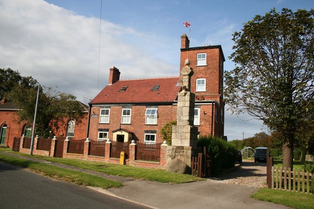
Fate we’re now at the main Junction in the middle of the village and if we continue South we come to what’s known as blacksmith’s Corner this features the war memorial this was erected in 1998 and it’s made of cobblestone Boulders and brick with a flag pole next to it
There’s another Memorial this one for an old windmill a mill was first recorded in easington in 1260 and a mill was operational until the late 1920s it was finally dismantled in the 1960s rounding blacksmith’s Corner means passing blacksmith Cottage that’s this house with the signboard up next is the second Pub The
Marquis of grandby which sits in the shadow of the church on North Church side this is the larger of the two pubs and is geared more towards food than the White Horse this also offers some B&B type accommodation too there are two landmarks left the first one is an empty
Old foone box unusually red for the East Riding then there’s a row of houses on the left hand side which are the Coast Guard Cottages which sport a tower and a clock at one end in a moment we’ll see something else that’s related to these Okay so we’ve successfully made it
Around easington and to be honest with you if that was the only thing in this Parish that would be a nice little episode wouldn’t it however easington is definitely not the only thing in this one because we have to go to a place now called Kil which is to the south of
Easington now that’s a long linear village and we’re going to drive through it we’re going to end at a pub but the road doesn’t stop there before we leave easington there’s a couple more landmarks on the left here you’ll see a house with an unusual Monument by its gate it’s a former Coast
Guard Tower and it dates from 1867 after the tower the road splits into two pieces one heads South to KY the other goes to easington beach a stretch of shingle popular with Walkers as with many other holderness Villages the coastline here is ever changing as
You can see the road comes to an abrupt stop where some of it has been washed away by Coastal erosion the road to the beach only really has one other feature and that would be a caravan park or two because anywhere that’s near the sea
It’s bound to have one of those this is the easington beach Caravan Park parts of which it has to be said are perilously close to the cliff Edge anchoring the site is the Long Beach Club the building to the right of your screens now now we’re heading down fth
Home road towards KY which is lost and is still losing land to the Sea the annual loss varies between 1 and 3 yards annually when it was recorded in the Doomsday Book KY was several miles from the sea and its dwellings were on a hill old KY was swept away and effectively
This is new KY before the loss of the Old Village it had several Al houses shops and even a school between 1826 and 1831 its Church dedicated to St Helen fell into the waves to replace it a new church was built thanks to funding from Trinity house to this day the body which
Holds responsibility for the construction of ligh houses in the UK the new church built in the 1860s still stands today but it was declared redundant in 1993 and ever since that point keny has officially been a hamlet after the New Village was created it never got any larger than about 30
Houses though it did manage to retain two public houses the Blue Bell and the Crown and Anchor modern features also include the KY Wetlands Nature Reserve which provides waiters from the Humber mud flats with a place to roost at high tide KY is perhaps best known for having
A piece of military infrastructure which we’ve so far never come across this is the KY Sound Mirror which was used during World War I sound mirrors Go by different names some people call them acoustic mirrors or whisper dishes and when they’re found in peirs they referred to as whisper galleries their
Purpose was to detect incoming enemy aircraft by listening for the sound of their engines they acted as early warning devices and had a pipe known as a collector head in front of them which held a microphone they were mostly ineffective though as the speed of the average aircraft increased during the
1930s most were already too close to engage by the time they’d been detected by a Sound Mirror some of these can be found on the south coast but to find one on the east coast is much rarer KY Sound Mirror stands at 4 and 1/2 M high and
It’s on private land it can clearly be seen though from the road into KY and can also be seen from a public footpath which runs close to its sight on the other side of Ky Wetlands now the road we’ve just driven down is the one straight ahead of us and
To the left is sperm point and that is where I’m going now you can’t drive down sperm Point anymore you used to be able to but these days they’ve stopped you from doing that so you either have to walk it or you have to use a bike and
I’ve got a bike because you saw at the beginning of this episode me get this bike from Trevor houseal thetic games recycles so we’re going to set that up and we’re going to cycle down sperm point now it’s a long way a very very long way it’s longer than it looks on
The map to walk it it would take you an hour from this point to the other end and another hour back now of course I don’t have that amount of time which is why I have the bike I should in theory be able to do the whole thing inside an
Hour fingers crossed fingers crossed and of course this weather is not the best best is it but you know it is what it is uh I’ve got a raincoat on I’ve got plenty of you know warm clothing on so I should be all right I suppose it’s about
4 miles from this point here to the end of sperm point and then of course 4 miles back again so 8 miles on the bike let’s go just before we get moving I should stress that here I opted to use my gopro’s headstrap because attempting to
Carry the tripod on the bike would have been an impossible task I’d never before used the headstrap so I had absolutely no idea what this footage was going to be like so here we go then down the spurn Heritage Coast the first half a mile is a simple enough road but soon
After passing the brand new spurn Discovery Center on the right it becomes a concrete Causeway spurn is what’s known to geography as a spit a long thin stretch of land where all the eroded material from further up the coast is deposited this happens thanks to a phenomenon known as Longshore drift as
The north Sea’s energy begins to diminish as it meets the Humber it can no longer sweep the material it carries along with it meaning it washes ashore the result is spurn the flimsiest narrowest piece of land anywhere in the UK whilst the sea has created this it’s
Begun to destroy its own work okay so I’ve hopped off the bike here just for a second because part of this route you have to cycle on a beach sort of a beach anyway so you can see the North Sea to the left there the wind farm in the distance and
It’s also on the right as well it’s more the Humber on the right though isn’t it so here’s the beach coming up you can see that the the road kind of stops and you have to go along the beach for a bit but the road does
Rejoin on the other side to get down to the Nature Reserve so that’s effectively where we’re going look how rough that sea is today it’s amazing isn’t it right let’s carry on the road used to run all the way to the end it’s now in two pieces thanks to
A tidle surge which washed away a huge chunk this area is known as the Bree or the washer over zone I’m not going to lie folks this is probably the hardest thing I’ve ever done I’ll be honest with you the ligh houses are still quite a
Way away in the distance over there but uh having to push this push this bike along the beach is really difficult there’s no way I can cycle on it it’s just too difficult to do but like I said we get towards that Cliff you can see over there the road
Reappears and we should be okay for the last push towards the lighthouses and towards the Nature Reserve at the other end he said hopefully okay we’ve made it to the road again that is the hardest thing let me tell you the hardest thing I’ve ever done on this channel pushing
This bike along the beach I’ve got to do the way back as well yet let’s continue then let’s find those lighthouses before the tidal surge cars were allowed to drive all the way to the end of spurn now though with no Road in the washover zone visitors face an arduous Journey to
The other end either by foot or by bike the causeway was built during World War I and it’s wethered many a storm in its time but during the surge in 2013 part of it was ripped away in less than an hour it’s frightening just how much
Damage Mother Nature can do at high tide The washover Zone can become inundated with water effectively turning this part of spurn into an Island thankfully though visitors are still allowed look to the right here and you can see what looks like a lagoon spurn isn’t straight it’s a gentle curve which bends
Westwards into the Humber that’s all to do with the direction of the prevailing wind as the spit formed with the eroded material from the coast deposited on the outer Ark a salt marsh consisting of mud and silt has formed on the inside of the curve due to the low energy in the
Waters of the Humber geographers call this kind of phenomenon a sheltered estery the deposited material has formed sand dunes right the way along spurn these have been colonized by vegetation particularly maram grass which is the greenery you can see all around you it’s not a desolate Wasteland either most of
It is designated as a nature reserve most notably the area at the very far end it’s not uncommon to see plenty of bird watches on spurn and that’s why the pubs in easington and ksey do so well for themselves as well as a road spurn also used to have a railway parts of
Which can still be seen you may have noticed rails in the road a couple of times already conventional engines were not used here though instead unusual sail Bogies were used as well as more conventional light Railway equipment after about 3 and 1/2 miles of walking and cycling the first real interesting
Landmarks come into view the lighthouses spurn has had a few lighthouses over the centuries the earliest reference to one goes back to 1427 the ones standing here today are much more modern the black and white lighthouse on your screens now dates from 1895 it’s not used anymore since it was decommissioned
In 1985 it does open for tours though at certain times of year initially oil lit it was converted to electricity in 1941 to enable the light to be lit briefly when requested by ships it was built to replace two former lighthouses which were built by John smeton in 1767 known
As the highlight and the low light smen’s highlight was a 90t hour which remained in use until the new one was built the low light suffered severe problems with maintenance and within a short time it had been washed away by the Sea a series of temporary Replacements were used in the years that
Followed until a more solid Lighthouse designed by James Walker was constructed in 1852 under the supervision of engineer Henry Norris unlike its predecessor the low light was built on the Humber Ester side of spurn rather than on the seawood side that structure still stands today although its Lantern
Has been replaced by a water tank we’ve now reached the very end this area is known as spurn head which covers about 280 Acres above high water it’s been owned by the Yorkshire Wildlife trust since 1960 and forms part of the Humber Flats marshes and Coast special protection area it’s here where you’ll
Come across something you might not have expected houses you see since 1810 sper head has had a Lifeboat station owing to the remote location houses for the Lifeboat crew and their families were added a few years later by the 8 1970s a room in the high Lighthouse was being
Used as a chapel for the small residential Community who lived here serving the keepers the coast Guardsmen and the fisherman however nobody lives here now permanently given that spurn is effectively a tidal Island The Jetty which you can see here was for launching the lifeboats an inspection in February
2023 revealed this had structural issues and as a result the station was moved to Grimsby there are wartime relics down here too during the first World War Two Coastal artillery 9.2 in batteries were added at either end of sper head with four and 4.7 in quick firing guns in
Between the northern ones are particularly interesting as Coastal erosion has partially toppled them onto the beach revealing the size of their concrete foundations we would have been able to see them in a bit more detail but as I was soon to find out we couldn’t actually go any further than
Here we have traveled though almost to the very end of the East Riding well it looks like people that’s as far as we can go because there’s a a fence now blocking the uh the road off um I don’t think we’re we’re that far from the very
End actually to be honest with you I’ll just have a quick check of my uh my phone because this will tell me definitively how far away the end of sperm point is it’s just a a Nature Reserve at the very very far end um but
It looks like this is as far as we can go because there’s a a barrier there I I suppose suppose you could sort of you know walk through it or over it or whatever but I’m not going to do that yeah we’re virtually at the end if you
Look here look I don’t know whether you can see this but the blue blob on my Google Maps can you see that hopefully you can cuz I can’t see a thing cuz the gopro’s on my head it’s uh there it’s it’s almost right at the end so we we
We’ve almost made it all the way to the the land’s end if you like of the East Riding of Yorkshire which is pretty good I think we’ve done very well there and now I’ve got to take myself back so uh this should be easier in fact on
The way back because most of it will be cycling downhill as opposed to uphill which which is what it has been up to now what a beautiful place and how interesting it is fabulous despite now not being accessible by car to visitors I’m sure you will have noticed some Vehicles down
Here to get to sper head they have to drive along the beach presumably they belong to members of the Yorkshire Wildlife trust you have to make sure if you’re coming here that you don’t visit a high tide as it can cut you off from the mainland the Yorkshire Wildlife
Trust have installed a high tide shelter on spurn head though so if the worst does happen you do have somewhere safe to wait it out and you don’t need to park at the Bluebell Pub either like I did instead for a small fee you can park at the spurn Discovery Center which was
Opened in 2018 by Simon King the center’s construction was initially met with criticism from the locals because there was a perceived feeling that spurn was becoming commercialized well I think it needs it though spurn once featured on the television program seven natural wonders as one of the wonders of
Yorkshire having now seen it all from beginning to end in all its Glory a wonder it most certainly is to finish with we’re taking a look at the North Sea gas terminals it might be easy to think there’s only one of these when seen from afar but there are in
Fact four they just happen to be built so close to each other two of the plants are operated by BP centrica storage which processes and stores gas offshore and another is owned by Gasco who operate the langed pipeline between Norway and the UK collectively these are sometimes referred to as the easington
Gas terminals until the 1960s these were not even thought of it was 1965 when gas was first discovered under the North Sea by the first ever British oil rig the sea gem it found the West SO gas field which lies 42 Mi east of the Humber it’s
A faulted dome covering an area of around 36 squ Mi and it lies at a depth of 9,000 ft below the surface the natural gas within it is mainly methane gas was first produced from it in March 1967 and that same year BP opened the first of the four terminals dim lington
Is the largest site of the four and has the control room for all the North Sea fields that ship gas to easington all the sites are a consider able fire hazard so they have large water reservoirs for firefighting containing between 1 million and 3 million lers of water each the terminals are also
Protected by Ministry of Defense police officers as we drive away from easington we pass a tower with two bright red lights at top it I have no idea what this is there seem to be nothing out there about it so whether it’s anything to do with the gas terminals or whether
It’s something else entirely I don’t know anyway that’s been easington but before we move on to the next one I took full advantage of the darkness which had fallen pretty quickly by recording this 20c segment along patrington High Street on my way back to Hull look at the Christmas lights aren’t they magnificent
Next week we’ll be in another of the East ridings towns arguably the most historic one yet this side of Hull see you There Thanks for watching this video folks don’t forget to like this episode if you haven’t already it really makes a difference with YouTube if you’re new here subscribe to the channel for more videos like this and give us a share too if you’ve got friends who’d like it you
Can find all the links to my social media accounts below as well as my bu me a coffee page where you can donate to the channel also if you’ve enjoyed this episode have a look at some more videos in this series until next time I’ve been
Andy also known as The Village Idiot and I’m out
18 Comments
Thanks, Andy, been looking forward to this one. Shame the weather wasn't on your side, but that happens. Using the bike courtesy of Trevor worked well, I think. I am a member of the Yorkshire Wildlife Trust, and anyone wanting to follow your visit might be interested in their bike hire, £10 per person per day. Access to both the Centre and Spurn National Nature Reserve is free, but some activities and events will incur an extra cost.
😂
Great episode. Hoping to visit Spurn point later in the year, so was lovely to see this. Well done on the bike!!
At least you can cycle up those hills instead of walking up them 🤣
Brilliant video we live down at sunk island behind the channel marsh
Spent many a weekend at Kilnsea .lovely video .sue 😊
Really enjoyed watching your video. Many times have passed through on the way to Spurn. Many thanks.
Hope the cycle went well for you a great film fantastic
Really good episode, Andy. I applaud you taking the bike down there in that weather. Not many of us locals around here have lol Lovely to see our Christmas lights at the end of the video, too 👏 It’s good to have it documented before it’s devoured by the sea, as it will be, sadly. It will join the list of lost places along our coast.
As a born, raised and present Dutchie, seeing a bike satisfies me. They're my main way of getting around; I don't have a driver's license and am not interested in getting one for the time being either. Must say I live too far from the sea to have ever done anything like this before though.
Great area Spur Point I am old enough to remember being able to drive down to the end . But i still enjoy walking to the end now.
Yey we got there at the end welcome to my home village
Welcome back to the ERoY..
I visited SpurnPoint on numerous occasions as I love that area but sadly the road to the lighthouse is now not passable..
Thankyou for the memories your video has given me..
Enjoyable, I walked this last Feb, the lot, now that was hard too.
I travelled the whole length in 1989 and got as far as Spurn head, I'd seen a programme saying it would get cut off in years to come. It certainly has changed.
Hi Andy.
Nice see Trevor .
A face to the name.
Costal … scary.
❤ old buildings.
Some interesting houses.
Amenities sports . Nice see.
Another great video.
Thanks.
Great video. The unusual vehicle parked near the visitor centre is the ‘unimog’ which is used to take visitors on tours of Spurn Point. Book with Yorkshire Wildlife Trust. Loved the Christmas lights in Patrington. Thanks Andy for your epic endeavours!
Last time I was down there, I drove to the end. There was a lifeboat station and the Humber Pilot boats used to go out from the jetty. I didn't realise the road had gone.